Radar and lightning detection
Precipitation estimation
Generation and Verification of Rainfall Estimates from 10-Yr Volumetric Weather Radar Measurements
Volumetric measurements from a C-band weather radar in Belgium are reprocessed over the years 2005–14 to improve the quantitative precipitation estimation (QPE). The data quality is controlled using static clutter and beam blockage maps and clutter identification based on vertical gradients, horizontal texture, and satellite observations. A new QPE is obtained using stratiform–convective classification, a 40-min averaged vertical profile of reflectivity (VPR), a brightband identification, and a specific transformation to rain rates for each precipitation regime. The rain rates are interpolated on a 500-m Cartesian grid, linearly accumulated, and combined with hourly rain gauge measurements using mean field bias or kriging with external drift (KED). The algorithms have been fine-tuned on 13 cases with various meteorological situations. A detailed validation against independent daily rain gauge measurements reveals the importance of VPR correction. A 10-yr verification shows a significant improvement of the new QPE, especially at short and long range, with roughly 50% increase in coverage. Adding the KED allows average improvements of 38%, 35%, and 80% for the mean absolute difference, the multiplicative error spread, and the fraction of good estimates, respectively. The benefit is higher in widespread situations and increases when considering higher rainfall amounts. The mitigation of radar artifacts is clearly visible on 10-yr statistics, including mean annual totals, probabilities to exceed 10 mm, and maxima for hourly and daily accumulation. The correlation of mean totals with rain gauges increases from 0.54 to 0.66 with the new QPE and to 0.8 adding KED.
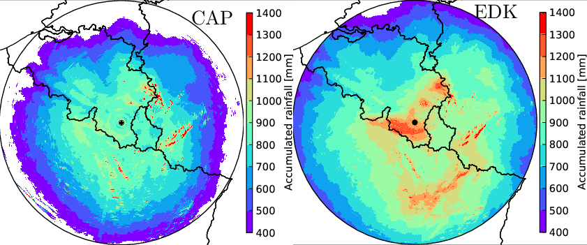
Annual total mean for the 2005–2015 period up to 220-km range based on a basic method (left) and the proposed method (right).
Evaluation of radar-gauge merging methods for quantitative precipitation estimates
Accurate quantitative precipitation estimates are of crucial importance for hydrological studies and applications. When spatial precipitation fields are required, rain gauge measurements are often combined with weather radar observations. In this paper, we evaluate several radar-gauge merging methods with various degrees of complexity: from mean field bias correction to geostatistical merging techniques. The study area is the Walloon region of Belgium, which is mostly located in the Meuse catchment. Observations from a C-band Doppler radar and a dense rain gauge network are used to estimate daily rainfall accumulations over this area. The relative performance of the different merging methods are assessed through a comparison against daily measurements from an independent gauge network. A 4-year verification is performed using several statistical quality parameters. It appears that the geostatistical merging methods perform best with the mean absolute error decreasing by 40% with respect to the original data. A mean field bias correction still achieves a reduction of 25%. A seasonal analysis shows that the benefit of using radar observations is particularly significant during summer. The effect of the network density on the performance of the methods is also investigated. For this purpose, a simple approach to remove gauges from a network is proposed. The analysis reveals that the sensitivity is relatively high for the geostatistical methods but rather small for the simple methods. The geostatistical merging methods give the best results for all tested network densities and their relative benefit increases with the network density.
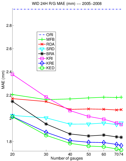
Mean absolute error of the merging methods for different network densities from 1 gauge per 500 km2(N=20) to 1 gauge per 135 km2 (N=74)