Radar and lightning detection
Lightning
In addition to operating the Belgian Lightning Location System (BELLS), lightning research plays a key role in understanding why and where lightning occurs, and what insights can be gained into atmospheric convection from the electrical activity in thunderclouds. The lightning team at RMI conducts research using different types of lightning data, i.e., ground-based and space-based instrument observations, on local as well as global scales.
Climatology
Numerous ground-based lightning location systems (LLSs) exist to date employing different types of sensors and detection techniques, enabling the user to detect cloud-to-ground (CG) and/or intra- and inter-cloud electrical activity. As such, it is possible to retrieve the geographical and frequency distribution of lightning on local, continental or global scales.
Whereas LLSs operating at the very low frequencies (VLFs) are able to detect lightning over large distances with a relatively low amount of sensors, these systems are limited in location accuracy (LA) and detection efficiency (DE). On the other hand, Lightning Mapping Arrays (LMAs) function at very high frequencies (VHFs), thereby restricting the range of observation to very local scales. LLSs operating at low frequencies (LFs), such as BELLS, combine the best of both worlds: with baselines of a few hundred of kilometers it is possible to cover countries as well as continents, while still retaining a satisfactory level of performance in terms of LA and DE.
While most LLSs provide supplementary information such as polarity and peak current of the lightning discharge, it is the spatial flash incidence that remains the main objective. This continuous interest in the spatial distribution of the lightning flash density Ng is not surprising as it is not only of importance for climatological studies, but plays a vital role as well in the risk analysis for protecting structures and electronic systems against damage from lightning impacts to ground (Poelman 2014; Poelman et al., 2016).
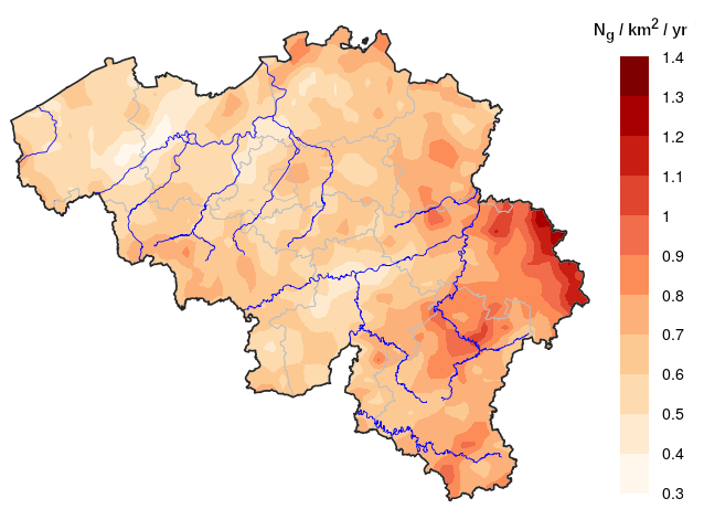
Geographical distribution of cloud-to-ground flashes Ng (/km2 /year) obtained by BELLS over the period 2004-2020.
Field campaigns
High-speed camera observations observe the light emitted directly by the lightning discharge, thereby documenting the flow of the electrically charged particles through the air, and provide, linked to electric field measurements, a means to investigate in great detail the associated optical and electromagnetic properties of natural downward lightning flashes. With frame rates of 200 s−1 (fps) or more, the different strokes that compose a multi-stroke flash can each be captured individually, while it is the electric field measurement that undisputably identifies the polarity of each stroke. Furthermore, video imagery enables us to determine, if not too distant and/or obscured by precipitation, whether each individual stroke creates a new ground contact point (NGC) or follows a pre-existing lightning channel (PEC). The characteristics deduced from this are not only relevant from a pure scientific perspective but are also essential in developing adequate lightning protection solutions as the level of lightning protection and risk to be mitigated is derived from the density of lightning terminations in a region (Poelman et al., 2013; Poelman et al., 2021a; Poelman et al., 2021b).
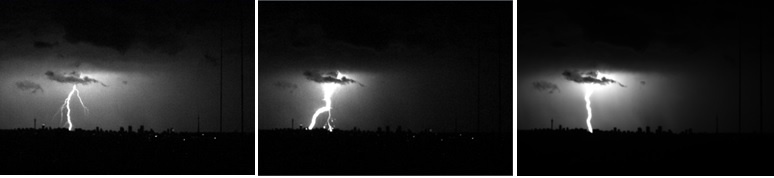
A lightning flash consisting of three different CG strokes observed in South Africa. Provided by Hugh Hunt and Carina Schumann (University Witwatersrand, Johannesburg, South Africa) and Tom Warner (ZT Research, South Dakota, USA).
Performance evaluation of Lightning Location Systems
Increasing possibilities for using lightning data necessitate proper spatial and temporal mapping of lightning events. It is therefore of importance to continuously assess the performance of a lightning location system (LLS) of interest in terms of the Detection Efficiency (DE), Location Accuracy (LA), peak current estimate and classification of the observed lightning type, i.e., negative versus positive and/or cloud-to-ground (CG) strokes versus intracloud (IC) pulses.
The most desirable way to do this is by using so-called ground-truth data. The latter can be gathered from direct hits to towers, measurements of rocket-triggered lightning, or via video and electric field (E-field) measurements. However, such ground-truth observations are not readily available at all times. Additionally, ground-truth campaigns are time-consuming because
enough data need to be gathered to be statistically relevant. Alternatively, intercomparison studies between LLS within regions of overlapping coverage offer an additional way to analyze detections made by one network in comparison to another (Poelman et al., 2013; Schulz et al., 2016; Poelman et al., 2017).
Space-based lightning observations
Satellite missions with dedicated onboard instruments provide a different way of capturing the stroboscopical dance of lightning discharges, i.e., cloud-to-ground (CG) and/or intra- and inter-cloud (IC) electrical activity, by observing the scattered light peaking through the top of the cloud. The signature of the strong optical oxygen triplet emission line at 777.4 nm is typically what is observed by means of specifically designed cameras. Although first attempts had already started in the 1970s, one had to wait until 1995 with the launch of the OrbView 1 (MicroLab 1) satellite with the onboard Optical Transient Detector (OTD), closely followed by the Tropical Rainfall Measuring Mission (TRMM) carrying the Lightning Imaging Sensor (LIS) in 1997, to witness the potential and significance of that type of mission. While the latter satellites moved in a polar orbit around the Earth, the latest and future types of optical lightning instruments are being put into operation from a geostationary (GEO) orbit, thereby expanding even further the range of associated applications. The research on this topic is timely given that the Meteosat Third Generation (MTG), which has a Lightning Imager (LI) on board, will probably be launched at the end of 2022 (Poelman et al., 2020).

The field of view of the MTG-LI instrument is covered by four identical cameras on the instrument, each covering one out of four domains on the observable Earth disk. Hence, MTG-LI will provide observations of the optical scattered light at the top of the clouds of the near-full Earth disk. In combination with the USA Geostationary Lightning Mappers (GLMs) and the Chinese FY4 Lightning Mapping Imager (LMI), a global picture of lightning activity is at our disposal.
The coverage of GEO sensors includes data sparse regions such as oceans and mountainous terrain, as well as countries that lack other means of observing thunderstorms, e.g., radar networks. These data open new perspectives such as detailed global lightning climatology with consistent performance over the next decades and further inter-comparison with ground-based lightning observations and other instruments. In addition, the continuous data flow can be assimilated in Numerical Weather Prediction (NWP) models to improve the localization of deep convection and consequently contribute to a better weather forecast. Finally, real time data allow for forecasts at very short range and the mitigation of risk due to heavy precipitation, flash floods, and severe weather.